Normandy World War II Sites
In my fairly large collection of books on World War II (most of which are in storage at the moment) there exists all manner of perspectives on the Normandy World War II D-Day invasion. I’d not prioritized seeing the actual sites of the invasion, doing more reading and research for some of my own writings on the North Africa and Italy invasions. However, when the opportunity to visit presented itself on a recent trip to France, I’m glad we took advantage.
There are many World War II Sites in Normandy to see, monuments and museums all up and down the coast. One could spend many days in the area exploring the D-Day sites, and sites from battles from the beachhead breakouts. After visiting Monet’s Giverny the day before, we left Rouen in the morning and had reservations at a hotel on Mont Saint-Michel that evening. Given that schedule we chose three sites to visit – and ended up at one additional museum and one additional monument by chance.
Omaha Beach D-Day Monument and Les Braves Sculpture
For logistics, we decided to drive to the furthest west of our chosen sites and make our way back. Upon further reading and reflection, I would have/should have gone further west to see Point du Hoc.
It was a two hour drive from Rouen to Omaha Beach, our second day in the rental car. I was finally regaining the muscle memory needed to drive a manual transmission (a nice little Clio).

As we drove up to the monument, looking for places to park, our first perception of Omaha Beach is of sand. It is a long beach, and my first thought (as I’m sure many others did the same) was how utterly terrifying it must have been to try to run the hundreds of yards from the water to the embankment while people you didn’t know were shooting at you. Two hundred and twenty yards of beach, if fact, lead up to bluffs 30-50 yards high. The Americans suffered around 2,400 casualties at Omaha Beach on D-Day.
On Omaha Beach, where the Americans expected to encounter one or two battalions numbering perhaps 1,500 men (Ultra was not perfect), 7,000 men of the veteran 352nd Division raked the oncoming Americans with machine guns, mortars and 88s pre-sighted onto every square meter of beach. Amphibious tanks swam toward the beach; of twenty-nine going in to Omaha, twenty-two sank with their crews; five were blown up. Now the combat engineers and infantry were wading and swimming and crawling ashore under murderous German fire.
The Last Lion by William Manchester and Paul Reid, page 842 (one of the 200+ World War II books in my collection, unfortunately most in storage)
When we visited, as with most places along the coast in July, there were many people enjoying the beach, 88 years and almost a month later.
The metal sculpture is called Les Braves (The Braves) by Anilore Banon. Installed on the sixtieth anniversary in 2004, It consists of three different parts:
Les Braves consists of three elements:
The Wings of Hope
So that the spirit which carried these men on June 6th, 1944 continues to inspire us, reminding us that together it is always possible to changing the future.
Rise, Freedom!
So that the example of those who rose against barbarity, helps us remain standing strong against all forms of inhumanity.
The Wings of Fraternity
So that this surge of brotherhood always reminds us of our responsibility towards others as well as ourselves.
On June 6th, 1944 these man were more than soldiers, they were our brothers.
From the sign near the sculpture, signed by Anilore Banon

There is a wonderful short movie on the sculptress’ website that shows the installation during high tide with waves crashing around it.
The memorial is simple and somber in contrast to the sculpture. Click on each image in the gallery below to view a larger image.


Omaha Beach Museum (Musée Mémorial d’Omaha Beach)
Anyone who drives to the Omaha Beach Memorial will pass the Musée Mémorial d’Omaha beach. It is hard to miss with the tank and artillery in the parking lot. We drove back to it after viewing the monument on the beach. This museum was not one of the original three on our list of places to visit, and we assume it would be a quick stop. We highly under estimated this museum.


In addition to the displays shown in the gallery above (again, clicking on an individual image will allow you to view a larger version), there were several collections – imagine the stories behind each. Below is a collection of medals, cigarettes, matches and other items.

There were several sets of photos from the invasion and the days following, set up in displays like the one below.

There were many collections of helmets and insignias.

There was even a barrel (well, mini-barrel) of Scotch. I’m assuming the soldiers were thirsty and the barrel was empty.

The Museum also had a movie, with some showings in English, some in French.
Omaha Beach was the site of one of two Mulberry Harbors, temporary portable harbors developed by the United Kingdom. The one at Omaha Beach, Mulberry A, was operational 10 days after D-Day, bringing in supplies, equipment and reinforcements and shipping out casualties. Three days later the largest storm to hit Normandy in 40 years started, and didn’t stop until June 22. The decision was made to abandon Mulberry A and use Mulberry B – which we visited as the last stop on our trip (see below).
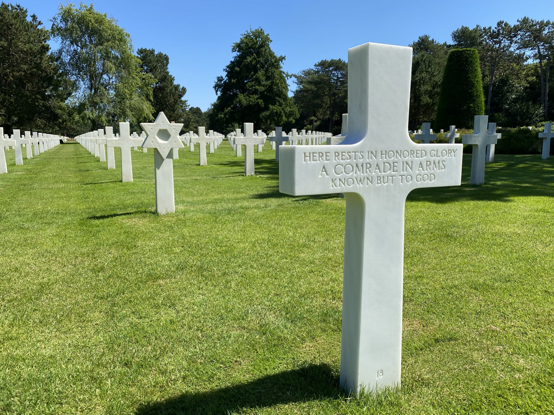
Normandy American Cemetery
After a brief lunch (a pizza at La Cremaillere), our third stop, the second of our planned ones, was the Normandy American Cemetery and Memorial. The Normandy American Cemetery is one of fourteen permanent American World War II cemeteries on foreign soil. The government of France granted use of this land, in perpetuity, as a permanent burial ground.

The Cemetery has 9,387 headstones of which 9,238 are Latin crosses and 149 are Stars of David. There are 45 sets of brothers and 3 Medal of Honor recipients buried there – one of which is Theodore Roosevelt Jr., the Presidents son. There are 304 unknown soldiers buried amongst their fellow servicemen.

Below is a video of the Memorial at the Cemetery with a view toward the chapel.
The Memorial has maps and explanations of those maps on both sides. Facing the memorial with the chapel at your back, the set on the right shows “The Landings on the Normandy Beaches and The Development of the Beachhead.” The set on the left shows “Military Operations in Western Europe 6 June, 1944 – 8 May 1945.” Click on any image in the gallery below to see a larger full-sized version.


In the center of the memorial is the statue “The Spirit of American Youth Rising From the Waves” by artist Donald De Lue.

To the east of the memorial and statue is a round wall, the Wall of the Missing, enclosing the Garden of the Missing. On the tablets in the wall are inscribed 1,557 names of those missing in action. A bronze rosette on one of the tablets shows those whose remains were recovered, identified and buried.

West of the memorial is a reflection pool with pathways that lead to a chapel and the west end of the cemetery. The perspective of the photo below to the east back towards the memorial.

The reflecting pool, chapel and path beyond separate the cemetery into two halves. There are five grave sections on either side, labeled A through J.

The two sculptures at the west end of the cemetery represent America and France.

Though the cemetery and memorial are the most inspiring parts, the visitors center has some excellent exhibits.


Big 1 Memorial (1st U.S. Infantry Division)

As we were driving out of the parking lot of the Cemetery en route to our third and final planned stop of Normandy World War II sites, we saw a crowd of cars around another memorial. Pulling in, we found the memorial to the Big Red 1, the 1st U.S. Infantry Division.

From a map near the memorial is this description:
On Omaha Beach, to your front, assault troops of the US First Infantry Division led the attack of V Cops, landing at 6:30am on June 6, 1944 (D-Day). The BIG RED ONE soldiers encountered beach obstacles and fierce enemy fire from the bluffs which stopped their advance at the water’s edge, an operation even more difficult than expected. Slowly, with support from naval gunfire, the Big Red One infantrymen advanced, with heavy casualties, to the top of the bluff on your left by late morning. At day’s end, V Corps had a tenuous toehold 1 1/3 miles deep on the Normandy coast.
During the next week, the First Infantry Division attacked south some 23 miles to capture the high ground around Caumont which it held until late July, when the successful breakout operation was staged.
Medals of Honor for conspicuous heroism were awarded to three men for June 6th and to two more for June 10th. The names of 627 soldiers on this monument remind us of the heavy cost of that victory. Again, the Big Red One lived up to its motto – <<No Mission Too Difficult, No Sacrifice Too Great, Duty First>>.
The 1st Infantry sign at the monument.
There were the remains of German defense bunkers all around this site. Of course I had to crawl through a couple.


For those of you who like maps (as do I!), the one below denoted where the German emplacements were in relation to the monuments. The memorial for the U.S. First Infantry Division is denoted by “A” on bottom left of the map. Click on the image for a larger version.

Down towards the beach there is a memorial to the Fifth Engineer Special Brigade. There have been six Engineer Special Brigades, with the First, Fifth and Sixth participating in the Normandy D-Day invasion. The First was at Utah Beach, and the Fifth and Sixth were at Omaha Beach,

This monument to the Fifth Engineer Special Brigade was built atop one of the many bunkers in the area. In the photo below it is obvious that no one would dare attack it now since my gorgeous wife was standing guard. According to the map in one of the previous pictures, this was a “Casemate for a Czech 7,65-cm field cannon model 1917.”

Arromamches (Musée du Débarquement) Museum of Embarkment
After securing the beachheads in Normandy, the problem of supplying those troops and the thousands to come was a high priority. The Allies believed correctly that it would be many days before they would overcome German defenses defending one of the working ports. And there was always the risk that in retreat the Germans could damage the port. Thus the plan after D-Day was to build two Mulberry ports.
To maintain an infantry division to challenge the enemy would require supplying it with 300 to 400 tonnes each day; an armored division would need 1,200 tonnes. During the early stages of the invasion, given the size of the forces deployed, the supplies required to cross the Channel would amount to between 8,000 and 12,000 tonnes per day, without taking into account the need for forces to consolidate on the bridgeheads.
Arromanches: History of a Harbour, Mulberry Harbour 1944, page 3
There would also be the unfortunate need to evacuate the wounded.
The Museum of Embarkment has models of the Mulberry port that was built there, in a building that looks out over the remains of Mulberry B.

The back cover of the book Arromanches: History of a Harbor says “The construction of the Mulberries was probably the greatest military engineering enterprise untaken since the Persian armies crossed over the Bosphorous on a pontoon bridge, in B.C. 480.”
These artificial ports and harbors had to operate with the tides, i.e., unloading heavy supplies on top of moving water. The model in the Museum simulates the water moving and shows how the constructed port responds.
The design and construction for these artificial ports started in 1941, and Churchill wrote a memorandum about amphibious warfare techniques and installing unloading quays on beaches. The pieces needed to construct the port were built in England and towed across the English Channel.
The video below was taken from outside the Museum, and shows some of the remains that are still in place and in view today.
The photo below shows a closer view, including some folks wading out in between the remains for the Mulberry port.

This was the end of our roughly five and a half hour tour of some of the many Normandy World War II sites. We left Arromanches around 5:30pm. By 7:30pm that night, we could see Mont Saint-Michel – our home for the next two nights!
Related posts:
 Central Museum of the Great Patriotic War (ЦЕНТРАЛЬНЫЙ МУЗЕЙ ВЕЛИКОЙ ОТЕЧЕСТВЕННОЙ ВОЙНЫ) Map-Guide Translation from Russian to English
 Map Translation – the Central Museum of the Patriotic War (ЦЕНТРАЛЬНЫЙ МУЗЕЙ ВЕЛИКОЙ ОТЕЧЕСТВЕННОЙ ВОЙНЫ)
 Piskaryovskoye Memorial Cemetery, Saint Petersburg and other monuments to the Siege of Leningrad
 National Museum of World War II Aviation